
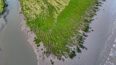
The monitoring of coastal ecosystems, such as salt marshes, has undergone a radical transformation thanks to the integration of high-resolution drones and advanced artificial intelligence models. A paradigmatic example is the EcoVision conceptual system, which combines RGB images taken from UAVs with a modular pipeline of transformer-based semantic segmentation, vegetation extraction via connected components, and fine-grained species classification using ConvNeXt architectures. This approach enables the generation of dominance maps for halophytic species such as Spartina maritima and Puccinellia maritima at 2x2 meter resolutions, achieving pixel-level accuracies of 96% and an F1 score of 0.99 in object classification. The results are comparable to traditional field quadrat methods, with differences of less than 8%, demonstrating the feasibility of scaling this type of analysis to large areas.
Behind solutions like EcoVision lies intensive work in custom software development and integration of AWS and Azure cloud services to process the terabytes of data generated by flights. Companies looking to implement similar systems need both cloud infrastructure and AI agents capable of executing inference in real-time or in batches. In this context, having a technology partner like Q2BSTUDIO is key: we offer artificial intelligence services for businesses, designing customized pipelines that range from image acquisition to generating dashboards in Power BI. Our experience in business intelligence and custom application development allows us to transform pixel predictions into interpretable ecological metrics, exactly as EcoVision proposes.
Furthermore, cybersecurity is a fundamental pillar when handling sensitive biodiversity data or critical assets. We implement security protocols at every layer of the system, from drone capture to cloud storage. We integrate business intelligence services with Power BI to visualize vegetation trends, and deploy AI agents that automate classification tasks and early warnings. All of this follows a modular approach that can be adapted to different species and geographic scales. If your organization needs a robust, scalable, AI-based environmental monitoring system, we invite you to explore our capabilities in AI for businesses, or learn how we develop custom applications that turn complex data into strategic decisions.